

Continuous Monitoring of Nature Conservation in the Lower Oder Valley National Park
Objective
Why the continuous monitoring of conservation in the National Park?
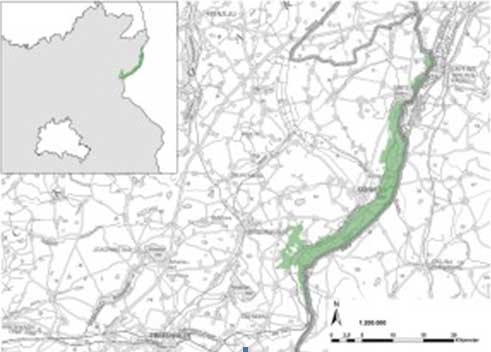
Lower Oder Valley National Park is Brandenburg’s only national park and unique nationwide as the only river national park. Its territory stretches for about 50 km along the Oder, which marks the boarder between Germany and Poland.
Since the foundation of the National Park in 1995, the area that was previously used for intensive agriculture has changed considerably due to the lack of or extensive farming. The Lower Oder Valley National Park Act (NatPUOG 2006) describes the protective purpose and development goals, which are pursued by the designation of the lower Oder valley as a large conservation area. A documentation of these processes and changes is legally anchored within it.
The continuous monitoring must clarify the degree to which the conservation and development goals are achieved, and simultaneously observe national and international requirements (national biodiversity strategies, Federal Conservation Act, IUCN, Natura 2000, EU-WRRL)and comply with their reporting requirements. In addition, the programme facilitates fundamental research, in which the change from land previously used commercially to near-natural habitats hardly affected by humans, is documented in order to better understand these processes and their effects. The results of the continuous monitoring are issued in regularly published reports the next publication is planned for 2018.
What goals are being pursued?
In § 3 of the Lower Oder Valley National Park Act, the protective purpose of the National Park is defined. The purpose is to “protect, maintain and preserve the floodplain landscape with its species-rich animal and plant population, the numerous wetland habitats, pastures and lowland forests as well as the hillside forests accompanying the flatlands in combination with other forests and the dry grasslands and to develop it naturally” (§ 3 para. 1 NatPUOG).
In keeping with this, the goals for continuous monitoring of nature conservation were formulated:
- Monitoring the developments, especially the succession in the total reserve area
- Monitoring the development of the water regime of the river and meadow
- Monitoring the development of the water quality of the Oder
- Monitoring the development of the surface filter effect of the pastures
- Monitoring the development of the various water types of the meadow areas
- Monitoring the development of the habitat qualities in the meadow areas with different characteristics
- Monitoring the development of the dry grassland sites on the hillsides
- Monitoring the development of the near-natural forests, especially the hillside and lowland forests
- Monitoring the development of the forest areas
- Monitoring the development of the habitat quality in the other biotopes
- Monitoring the development of all levels of biodiversity across the territory of the National Park, in particular the species listed according to SPA (Special Protection Areas) and FFH-RL (Flora and Fauna Habitats Directive)
Information about the project
On the following pages you can find further details about the project:
- Methods and Parameters – How are the data collected and evaluated? What parameters are considered?
- Project set-up and Employees – Who coordinates the project?
- Events and Conferences
- Writings and Publications – publications, research and graduate theses within the framework of the programme
If you have further questions about the project, please contact
Mrs Dr. Jana Chmieleski
jana.chmieleski@hnee.de
Telephone: +49 (0) 3334 657325
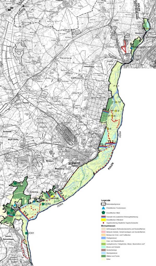
Titel: Continuous Monitoring Plots in the Lower Oder Valley National Park. Created by Ole Bauer, 29th August 2013
Methods and Parameters
Methods
How are the data collected and evaluated?
The analysis programme and the collection methods for the continuous monitoring of nature conservation in the Lower Oder Valley National Park (NLPUO) are described in detail in the Methodenkatalog zum Monitoring – “Catalogue of Methods for Monitoring” (Luthardt & Grübler 2011). The research programme was created at the HNEE Eberswalde in 2011 and adopted together with the National Parks Administration. Since this is a new methodological development, the programme is verified annually and, in justified cases, the programme is changed, expanded and adapted.
A description of all the methods applied would be too detailed at this point. If you are interested, please contact us.
For the continuous monitoring, hierarchically interconnected area plains were chosen:
- Total Area of the National Park
- Polder Areas with Adjoining Hillsides and Forests
- The Oder River
- Selected Types of Ecosystems
Area Level 1: Total Area of the National Park
Documentation of general landscape processes (changes in the biotopes, dynamics of the floodplain areas, developments wood coverage in time and space).
Area Level 2: Polder Areas (with Adjoining Hillsides)
On transects (T), changes are examined in detail as cross-sections through the floodplain via differentiated wetlands, soil types, land use or succession.
Area Level 3: The Oder
Also in river polder systems, a river affects landscape-changing processes (albeit to a much lesser extent than in a natural floodplain). Water quality, flow rate and speed and material load of the Oder are included in the monitoring evaluations.
Area Level 4: Selected Types of Ecosystems
Individual continuously monitored areas (individual areas: IA) are examined in order to document the differentiated development of selected ecosystem types in the National Park within the ecosystem’s context across the various compartments (grasslands, reeds/reed beds, shrub lands, still waters, forest areas).
Monitoring Goals and Parameters
Along with this hierarchical, in a broader sense “vertical”, division of the reference spaces into area levels, the national park was additionally divided into four groups for the continuous monitoring. The individual groups differ in biotopes, management measures and/or their conservation goals. Therefore, different parameters are considered:
I. Monitoring the development of the currently wooded and open areas in the total reserves of Zone Ia II. Monitoring the development of the presently open land areas in Zone II and Zone Ib III. Monitoring the changes of the Oder, West Oder, Hohensaaten-Friedrichsthaler Waterway IV. Monitoring the development of the landscape diversity in the area
The monitoring goals of these four groups are summarized in the boxes below. In addition, parameters were set (and according to which methodology and at what interval these should be collected) for each monitoring goal. You can find the details in Part B of the Luthardt & Grübler (2011) prepared Methodenkatalog for the continuous monitoring of nature conservation in the Lower Oder Valley National Park.
I. Monitoring the development of the currently wooded and open areas in the total reserves of Zone Ia
Monitored are the change(s) in:
- Levels of succession in terms of classification, area size, number and condition
- Habitat suitability
- Species composition (character types or indicator species of biotope types according to the biotope mapping guidelines of Brandenburg; Neophyta / Neozoa)
- Population sizes of selected target species
- Regional water supply
- Soil acidification in the forest areas
- Occurrence od biotic pests in the forest areas
- Depth of still and flowing waters
- Location and size of still and flowing waters
- Nutrient content and acid/base ratios in the still and flowing waters
- Vegetation zoning in the still and flowing waters
- Phytoplankton in the still and flowing waters — currently not covered for still waters
II. Monitoring the development of the presently open land areas in Zone II and Zone Ib
Monitored are the change(s) in:
- Vegetation structures
- Classification, area size, number and condition of the biotope types
- Species composition (character types or indicator species of biotope types; Neophyta und Neozoa)
- New occurrences of mass multiplication of individual species with effects upon the ecosystem*
- Regional water supply (groundwater, flooding, soil moisture)
- Use of dry grasslands
- Population sizes of target species of the dry grasslands
- Input and output of nutrients in the floodplains and the dry grassland locations
- Humus and heavy metal content of the floodplain soils
- Location and size of still and flowing waters of the floodplains
- Depth of still and flowing waters of the floodplains
- Nutrient content and acid/base ratios in the still and flowing waters of the floodplains
- Vegetation zoning in the still and flowing waters of the floodplains
- Changes to the phytoplankton in the still and flowing waters of the floodplains
- Fishing and water maintenance in the still and flowing waters of the floodplains
III. Monitoring the changes of the Oder, West Oder, Hohensaaten-Friedrichsthaler Waterway
Monitored are the change(s) in:
- Frequency of high and low water
- Annual cycles of the water levels
- Habitat quality
- Vegetation structures
- Species composition (especially fish fauna)
IV. Monitoring the development of the landscape diversity in the area
Monitored are the change(s) in:
- 1. Distribution of plant formations
- 2. Length and classification of borderlines
- 3. Isolation, fragmentation, networking
- 4. Population size and the appearance of defined target species
References: :
LUTHARDT, V. & F. GRÜBLER 2011: Methodenkatalog zur naturschutzfachlichen Dauerbeobachtung im Nationalpark Unteres Odertal. 1. Ausgabe, unveröff., i. A. des LUGV Brandenburg, Eberswalde.
Writings and Publications
Graduate Theses
Miranda Muffel |
Warum die Stachelgurke im NLP UO nervt |
Bachelor thesis, |
Max Backoff (2014): „Der Crussowgraben und seine westlichen Zuströme. Empirische Untersuchungen zu Qualitätskomponenten und relevanten Einflussfaktoren eines Fließgewässersystems in Brandenburg“
Jörn Bowitz (2014): „Sukzessionsverlauf auf Ackerbrachen in Brandenburg nach Nutzungsaufgabe – Einrichtung einer Dauerbeobachtung im Nationalpark Unteres Odertal
Mika Diop (2015): Regenwurmbesatz (Oligochaeta: Lumbricidae) und seine Beziehung zu den Bodeneigenschaften entlang eines Transektes durch einen Überflutungspolder der Oderaue im Nationalpark Unteres Odertal
Michel Hannemann (Geoökologie Uni Potsdam) (2013): Vom Forst zur Wildnis: Boden- und Waldentwicklung im Nationalpark Unteres Odertal
Elisa Kallenbach: bitte recherchieren
Lars Kalweit (2016): Einfluss unterschiedlicher Grünlandbewirtschaftung auf den Lebensraum des Wachtelkönigs (Crex crex) am Beispiel einer Untersuchungsfläche im Nationalpark Unteres Odertal
Franziska Kühne: bitte recherchieren
Heidi Lehmann (2014):„Entstehung, Entwicklung und heutiger Zustand der Moore bei Gellmersdorf im Nationalpark Unteres Odertal
Henrike Lorenz (2014): Gehölzstrukturen im nationalpark Unteres Odertal – Entwicklung eines Monitoringkonzeptes
Eva Manthey (2015): Kohlenstoffvorrat der Auenböden des Nationalparks Unteres Odertal und deren CO2-Austragspotentiale
Matthias Merkel (2012): Gewässerstrukturgütekartierung des Gellmersdorfer Grenzgrabens im Nationalpark Unteres Odertal
Arne Reck (Geoökologie Uni Potsdam) (2013): Vom Forst zur Wildnis: Boden- und Waldentwicklung im Nationalpark Unteres Odertal
Meike Schulz (2014): Untersuchung von anthropogen angelegten Pionierstandorten im Trockenpolder Lunow-Stolpe“
Marius Stapelfeldt (2016): Primärsukzession und Initialbodenbildung auf einem Rohbodenstandort in einem Nasspolder des Unteren Odertals
Dirk Wendicke (2015): Einsatzmöglichkeiten von Kleinfluggeräten (Drohnen) für das naturschutzfachliche Monitoring am Beispiel des Nationalpark Unteres Odertal – Möglichkeiten und Grenzen
Other Publications
Monitoringbroschüre (deutsch & polnisch)
Hirsch & Köhler (2016): XXXXXX
ckoff (2014): „Der Crussowgraben und seine westlichen Zuströme. Empirische Untersuchungen zu Qualitätskomponenten und relevanten Einflussfaktoren eines Fließgewässersystems in Brandenburg“
Jörn Bowitz (2014): „Sukzessionsverlauf auf Ackerbrachen in Brandenburg nach Nutzungsaufgabe – Einrichtung einer Dauerbeobachtung im Nationalpark Unteres Odertal
Mika Diop (2015): Regenwurmbesatz (Oligochaeta: Lumbricidae) und seine Beziehung zu den Bodeneigenschaften entlang eines Transektes durch einen Überflutungspolder der Oderaue im Nationalpark Unteres Odertal
Michel Hannemann (Geoökologie Uni Potsdam) (2013): Vom Forst zur Wildnis: Boden- und Waldentwicklung im Nationalpark Unteres Odertal
Elisa Kallenbach: bitte recherchieren
Lars Kalweit (2016): Einfluss unterschiedlicher Grünlandbewirtschaftung auf den Lebensraum des Wachtelkönigs (Crex crex) am Beispiel einer Untersuchungsfläche im Nationalpark Unteres Odertal
Franziska Kühne: bitte recherchieren
Heidi Lehmann (2014):„Entstehung, Entwicklung und heutiger Zustand der Moore bei Gellmersdorf im Nationalpark Unteres Odertal
Henrike Lorenz (2014): Gehölzstrukturen im nationalpark Unteres Odertal – Entwicklung eines Monitoringkonzeptes
Eva Manthey (2015): Kohlenstoffvorrat der Auenböden des Nationalparks Unteres Odertal und deren CO2-Austragspotentiale
Matthias Merkel (2012): Gewässerstrukturgütekartierung des Gellmersdorfer Grenzgrabens im Nationalpark Unteres Odertal
Arne Reck (Geoökologie Uni Potsdam) (2013): Vom Forst zur Wildnis: Boden- und Waldentwicklung im Nationalpark Unteres Odertal
Meike Schulz (2014): Untersuchung von anthropogen angelegten Pionierstandorten im Trockenpolder Lunow-Stolpe“
Marius Stapelfeldt (2016): Primärsukzession und Initialbodenbildung auf einem Rohbodenstandort in einem Nasspolder des Unteren Odertals
Dirk Wendicke (2015): Einsatzmöglichkeiten von Kleinfluggeräten (Drohnen) für das naturschutzfachliche Monitoring am Beispiel des Nationalpark Unteres Odertal – Möglichkeiten und Grenzen
Other Publications
Monitoringbroschüre (deutsch & polnisch)
Hirsch & Köhler (2016): XXXXXX
Events and Conferences
The results and findings of the continuous monitoring of nature conservation in the Lower Oder Valley National Park do not only serve the further development of the National Park’s management. They are intended to contribute to the scientific and nature conservation-specific discussion and to be debated in exchange with experts in order to draw conclusions for practice and research. Therefore, the results are presented at conferences and the administration of the National Park organises events in the lower Oder valley to promote this exchange.
If you are interested in a presentation of our results at your event, please fell free to contact us.
Previous Events
September 2016:
Data from the river – Conference on the floodplain in the Lower Oder Valley National Park. .Preservation and protection of floodplaind, 22nd-24th September 2016 in Criewen
Upcoming Events
The next event is planned for summer 2017. We will inform you about the detail here in a timely manner.
Projektaufbau & Mitarbeiter*innen
The programme and collection methods were developed at the HNEE in 2011 (Luthardt & Grübler 2011) and adopted together with the National Parks Administration. Since the programme set-up is a new methodological development, the concept is verified annually and, in justified cases, is changed, expanded and adapted.
The recording and evaluation work is coordinated and also partly carried out by the employees of the HNEE. The majority of the field surveys are handed over to external partners who possess the necessary expertise in the desired field. Some monitoring tasks are also carried out by the National Park Administration staff, the Nature Guard or volunteers of the national park and NGOs active in the national park.
Beyond that, data from external sources were obtained, such as the weather data from the German Meteorological Service (DWD), data on air quality from the Land Office for the Environment (at that LUGV, now LfU) and the water quality measurement of the river water from the Waterways and Shipping Administration (WSV).
The funds for the continuous monitoring of nature conservation are made available by the National Park Administration of the Lower Oder Valley from the budget of the state of Brandenburg.

Project Manager: Dr. Jana Chmieleski
Roomm: 01.318 (City Campus)
Telephone: +49 (3334) 657 325
Fax: +49 (3334) 657 282
E-Mail: Jana.Chmieleski@hnee.de

Laura Danzeisen
Room: 01.303.1 (Stadtcampus)
E-Mail: Laura.Danzeisen@hnee.de
References::
LUTHARDT, V. & F. GRÜBLER 2011: Methodenkatalog zur naturschutzfachlichen Dauerbeobachtung im Nationalpark Unteres Odertal. 1. Ausgabe, unveröff., i. A. des LUGV Brandenburg, Eberswalde.